I want this done by Tue evening. On Wed I will put up the mark scheme for the question. You will then have until Friday to reply to a post with a comment on what they have done, what they need to improve and a mark. Be honest, not mean or rude.
Any questions, email me.
(ii) Describe the distribution of earthquakes shown on Figure 4a.
Use evidence from Figure 4a in your answer.
(4)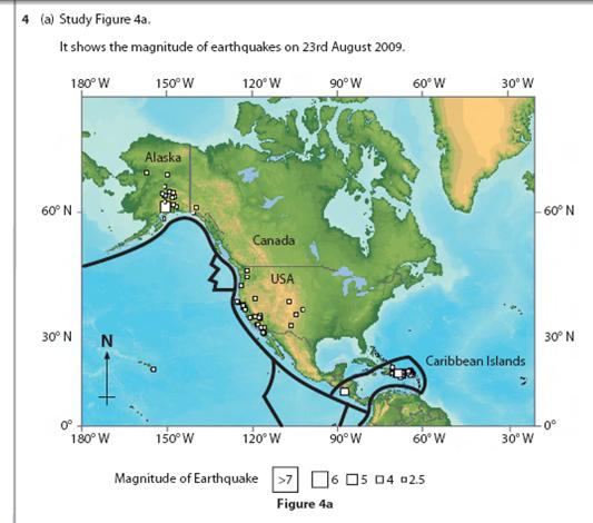

Figure 4a shows where earthquakes occurred on the 23rd of august 2009 and what the magnitude of the earthquakes is in each specific area. Southern Alaska appear to have had had the largest earthquake in one area with a magnitude of 7. The Caribbean islands appears to have also suffered serious earthquakes with its highest magnitude of 5. The USA has only revived minor small earthquakes (in the west) with a highest magnitude of 4. This diagram shows where earthquakes affect places the most. This is most likely because these places are closer to where the plates meet that have caused the earthquake.
ReplyDeleteI think this response is a clear and straight forward answer to the question. I believe it is worth 4/4 because you have conveyed that they are in a specific area (1 mark) you have told us they are near the plate boundaries (1 mark. As well as that, you have told us where they are (1 mark) and you gave evidence and data (1 mark) therefore it is a full 4 mark answer.
DeleteThe distribution of earthquakes on figure 4a are all located along the edge of the countries. most of the higher magnitude earthquakes are on the coast and the earthquakes closer to the center of the country are much lower magnitude.
ReplyDeletethe highest magtitude earthquake was in southern alaska and was alone the coast. this diagram shows the area of earthquakes and suggests it is due to plate boundaries.
+1-Near Coast
Delete+1 At the plate boundaries
+1 Linear
3/4
Southern Alaska has had the most earthquakes with one being a magnitude of 7. The west coast of America has had a lot of minor earthquakes that are a magnitude of 2.5. The caribbean islands have had a lot of minor earthquakes and one with a magnitude of 5. The diagram shows which places are most affected by earthquakes. This is due to conservative plates.
ReplyDeleteMost of these earthquakes have been occurring on, or close to major tectonic plate boundaries. The most powerful earthquakes have occurred in Alaska, (Mag. 7) and in the Caribbean (Mag. 4). There have been many minor earthquakes of around Mag. 2.5 primarily on the West coast of the continent, but some inland.
ReplyDeleteThis comment has been removed by the author.
DeleteYou've mentioned that the earthquakes have been occurring at the plate boundaries and you have also mentioned that they occur near the coast, but also inland. However, you haven't said that the earthquakes mainly occur in western USA and Alaska.
Delete3/4
(I have...)
DeleteThe distribution of earthquakes are close to tectonic plate boundaries. Southern Alaska has had the most powerful earthquake, with one having a magnitude of 7, at 150 degrees West and 60 degrees North. It has also had less powerful earthquakes in the South and also inland, with magnitudes of 2.5. The USA has had many minor earthquakes along the West coast and inland, but all at a magnitude of around 2.5. On the Caribbean Islands there have been many minor earthquakes in the North-East, with one earthquake having a magnitude of 4. There has also been a more powerful earthquake in the South-West of the Caribbean Islands, with a magnitude of 5, at around 92 degrees West and around 15 degrees North.
ReplyDeletePlate Boundarys - 1
DeleteUSA - 1
West coast (Sea) - 1
3/4
In the source we can see the smaller magnitude earthquakes are distributed evenly down the Western coast of US and larger earthquakes prominently in the Caribbean Islands. We know this because the larger the square the higher the magnitude of the earthquake and there are at least earthquakes of a 6 magnitude and many of lower power. As well as that, in the middle of the south coast of Alaska there are smaller 2.5 magnitude earthquakes spread out and 1 larger magnitude earthquake.
ReplyDelete1- West coast
Delete1- Alaska and USA
1- clustered
The distribution of earthquakes is mainly along the west coast of the U.S and Canada. This is because this is where the tectonic plate boundaries are and so they are more prevalent. The magnitude of earthquakes is fairly low along the U.S at mainly 2.5. It increases however to 5 in the Caribbean isles and 6 in Alaska.
ReplyDelete1 - West Coast
Delete1 - Plate Boundaries
1 - Alaska and USA
3/4
[I do not really know how to answer this]
ReplyDeleteMost of the earthquakes are situated near the plate boundary, there is not much distance between earthquakes' and they do not stray far from the plate boundary. Most of these earthquakes are of a 2.5 magnitude, however in the Caribbean two earthquakes of a larger magnitude occur however I cannot see a pattern on the graph which led to this.
1 plate boundary
Delete1 clustered (not much distance between)
needed to mention about they are near the coast, they are linear/ or name the countries